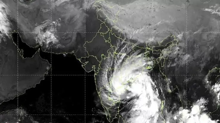
Cyclone Arnab Satellite Image : Cyclone Arnab has raised weather concerns after making landfall along the coasts of Andhra Pradesh and Yanam. An image from India’s weather satellite INSAT-3DS revealed a massive cloud system associated with the storm, extending across large parts of eastern and southern India. The image was captured between 9:30 AM and 9:57 AM on Wednesday. It showed dense clouds and extensive cloud bands stretching over a wide area. However, the spread of clouds across a large region does not mean every location will experience direct storm impacts. Even after landfall, several areas may remain at risk of heavy rainfall and waterlogging.
Cyclone Makes Landfall Along Andhra Pradesh Coast
According to the information provided, Cyclone Arnab crossed the coasts of Andhra Pradesh and Yanam on Wednesday, October 28. The process reportedly took place between approximately 2 AM and 8 AM. At the time of landfall, the cyclone’s sustained wind speed was reported to be between 125 and 135 kilometres per hour, while strong gusts reached up to 150 kilometres per hour. The storm’s centre was approximately 20 kilometres east-northeast of Narsapur, 40 kilometres southwest of Yanam and 60 kilometres southwest of Kakinada. After crossing the coast, the cyclone began moving inland.
What the INSAT-3DS Satellite Image Reveals
INSAT-3DS is an Indian weather satellite used to monitor clouds, cyclones and changes in weather conditions. Its image showed dense clouds appearing bright white. Such clouds are often associated with heavy rainfall and thunderstorms. Curved bands of clouds were also visible around the cyclone. These formations help explain the distribution and structure of clouds surrounding the storm. However, satellite imagery alone cannot accurately determine wind speeds or the amount of rainfall expected at ground level.
https://twitter.com/VU3BIZ/status/2115319042735313005
Why the Danger Continues After Landfall
Cyclones draw energy from warm ocean water while they remain over the sea. Once they move onto land, their access to heat and moisture from the ocean decreases. Land-based obstacles also affect their movement. As a result, a cyclone may gradually weaken, but its impacts do not disappear immediately. Clouds associated with the storm can bring heavy rainfall far beyond coastal areas. This creates the risk of waterlogged roads, flooding in low-lying areas and disruptions to everyday life.
Strong Winds Threaten Trees and Power Lines
During a cyclone, strong winds can uproot trees and damage electricity lines. Heavy rainfall can also cause waterlogging in low-lying areas and create flood-like conditions. It is important to monitor the direction in which the storm moves after landfall and identify the areas likely to receive rainfall. Satellite images help track the spread of clouds, while weather department forecasts help assess potential rainfall and associated risks. People living in affected areas should therefore pay close attention to weather warnings and official advisories.
Cyclone’s Further Movement Remains Under Watch
As Cyclone Arnab moves inland, it may gradually weaken, although the risk of rainfall could persist across several areas. The weather department assesses the evolving situation using information about the storm’s direction, wind speed and rainfall. Satellite imagery has revealed the extensive spread of clouds associated with the cyclone, but the amount of damage a particular area may experience cannot be determined from the image alone. Residents of Andhra Pradesh and neighbouring areas should remain cautious and follow local weather updates and instructions from the authorities.